It’s the most wonderful time of the year
When the bike tours are rolling
And friends are extolling you
Get it in gear
It’s the most wonderful time of the year
It’s the hap, happiest season of all
For winter’s too chilly
For a ride that’s this hilly
Late spring until fall
Is the hap, happiest season of all
There’ll be familiar faces
And lots of new places
For anyone wanting to ride
There’ll be pictures for taking
And new friends for making
Here’s hoping the shoulders are wide
It’s the most wonderful time of the year
When you ride in the Rockies
You shouldn’t be cocky
But nothing to fear
It’s the most wonderful time of the year
Sunday, December 20, 2009
Thursday, December 17, 2009
my favorite ride of 2009 (interdigitate)
Mike at The adventures of Mike and his Bike bike issued a challenge last week for any and all to write about their favorite ride/challenge of 2009. I had a lot of great days on a bike this year and had to give some thought as to what would be my “favorite”. I have already written about both tours I rode this summer, and while each had numerous high points, there were also a few things I might change.


On those tours I had some wonderful days, including riding through the Colorado National Monument, over the Grand Mesa, Slumgullion and Wolf Creek Passes. But for a day that had multiple challenges, spectacular scenery, beautiful weather, and an ending in a picturesque town surrounded by mountains, it would have to be Durango to Ouray, day 6 of the 2009 Colorado Rocky Mountain Bike Tour.

Seventy miles and almost 7000 feet of climbing! We started the day in the cool morning air, fog rolling off the Animas River as we rolled out of Durango. Gentle rollers were the trend for the first 10 miles, then the climbing started. A couple thousand feet over 10 miles before it leveled out. And we hadn’t reached a mountain pass yet! This was just the first rest stop of the day, near the Purgatory ski area at Mt Durango.
+of+IMG_0774.jpg)
Next, we headed up Coal Bank Pass at 10,640’, gaining another 2000 feet in less than 5 miles. What goes up must come down, and our first descent of the day gave back about 1000 feet in a couple of miles before climbing again to Molas Divide at 10.902’. The next 5 miles was a screaming descent down to Silverton at 9,308’.
+of+IMG_0825.jpg)


The final climb of the day was over Red Mountain Pass at 11,100’ gaining about 1800 feet over 12 miles. This was some of the most beautiful scenery I’ve ever seen from a bike seat. There were numerous places that you could look back and see where you had come from, and it was breathtaking. Getting to the top of the third pass, and fourth climb of the day was a great feeling of accomplishment. But there was still some fun left to be had.


A 3300’ drop from the top of Red Mountain Pass into Ouray, which tour organizers had described as “very steep, narrow and technical”. This stretch is called the Million Dollar Highway, and the views are easily worth that. After a day full of climbing, the last 13 miles was all downhill, literally. I spent much more time braking than pedaling, navigating one hairpin turn after another, needing to slow further as I entered Ouray coasting at 30mph past the 25 mph speed limit sign.

Ouray is known as the “Switzerland of America” and we spent our last night of the tour enjoying its charm and hospitality. A couple good meals, a nice cigar, and camping in the cool mountain air were a perfect ending to a great day on the bike.


+of+IMG_0774.jpg)
+of+IMG_0825.jpg)


Monday, December 14, 2009
new heights
Day 3 of the 2010 Colorado Rocky Mountain Bike Tour
---------------------------------------------------------
When riding in the mountains it is recommended that you start early enough to be up and off the summit of a high pass before noon to lessen the chance of hitting, or being hit by, inclement weather. I’ll have my lights on for this ride because I will want to get an early start. This day could be epic. You can’t ride any higher than Mt Evans, and this is one I really want to do. The ride from Idaho Springs to Echo Lake is a pretty good climb in itself, gaining 3000 feet in 14 miles, on roads curving through alpine forests.

When we reach Echo Lake we’ll want to stop for pictures. There’s a spectacular park with trails around the lake. Echo Lake Lodge offers souvenirs and cold drinks. And just past the lodge is the fee station for Highway 5, Mt Evans Road. The cost is $3.00 for a bicycle, and that gives you the privilege of another 14 miles of climbing, and about 3500 feet of elevation gain. I had hoped to ride up Evans last June, but was totally unprepared for the sheer magnitude of this ride. Kind of like going to Nepal and thinking, “while I’m there I think I’ll climb Everest”. This time I know what to expect.


After the descent, we’ll head east on Squaw Pass Road going over Juniper Pass and Squaw Pass. I can’t find a lot of information on these passes except that they’re not really passes. At least not the way we will be riding them. Apparently they are mountain passes going north and south, but the road going east and west rides on the ridges of these mountains. Anyway, not too much climbing from Echo Lake, already over 10,000 feet, then down into Golden. There will still be some awesome, challenging rides over the next few days, but if I can ride all the miles on this day, I'll be talking about it for a while.
---------------------------------------------------------
When riding in the mountains it is recommended that you start early enough to be up and off the summit of a high pass before noon to lessen the chance of hitting, or being hit by, inclement weather. I’ll have my lights on for this ride because I will want to get an early start. This day could be epic. You can’t ride any higher than Mt Evans, and this is one I really want to do. The ride from Idaho Springs to Echo Lake is a pretty good climb in itself, gaining 3000 feet in 14 miles, on roads curving through alpine forests.


Saturday, December 5, 2009
down the highway

Day2 of the CRMBT 2010 will depart from Frisco around the south end of Lake Dillon, also called Dillon Reservoir. This was originally a natural finger lake on the Blue River. In 1961 the city of Denver, needing a reservoir in the high country, built the dam to create the lake as it stands today. The original town of Dillon was located on the banks of the Blue River, and it’s said that remnants of the town are still visible from the Dam road and Swan Mountain Road. I’ll keep my eyes open as we head north over Swan Mountain. The road only reaches an elevation of 9455’, and having started at 9100’ in Frisco, this shouldn't’t be much of a climb.

Then we’ll jump on Highway 6 and roll into Keystone. Then the real climbing begins. In the same area where you can cross the continental divide on I-70 by driving through the Eisenhower and Johnson tunnels, you can choose Highway 6 and cross over Loveland Pass. From Keystone it’s about 10 miles and 2700’ of elevation gain to the top of Loveland Pass. The road is well maintained and the traffic is light, although this road is used by tanker trucks that are not allowed through the tunnel on I-70. The descent on the east side is shorter than the west side, but fast as it drops about 1000 feet over three miles.
I borrowed a couple pictures of Loveland Pass. I hope it looks like this:


Friday, December 4, 2009
happy birthday
Happy Birthday Mom!

I have an older brother, two older sisters, and two younger brothers. When I was young my Mom was a foster Mom for babies waiting to be adopted. Actually that's how we got my two younger brothers; they were too good to give up. And in the midst of all these children, my Mom had, and still has, a way of making you feel special.
I hope you have a great day, and we'll see you soon.

I hope you have a great day, and we'll see you soon.
Wednesday, December 2, 2009
a,b,c's of cycling colorado
These are some places I've visited, or plan to, and would recommend to anyone who wants to get to know Colorado up-close and personal:
A- riding through Aspen on the way to Independence Pass
B- Battle Hill Summit, a beautiful part of the Copper Triangle
C- Colorado National Monument "tour of the moon"

D- Durango, a great western town, and good starting point for some great rides
E- Mt Evans and Echo Lake, still waiting for me
+of+IMG_0221.jpg)
F- Frisco- bike, hike, kayak, sail, ski- you can do it all here
G- The Grand Mesa- the world's largest flat-top mountain

H- Hoosier Pass- south of Breckenridge
I- Independence Pass- my first really big climb

J- Juanita Junction- a wide spot in the road between Hotchkiss and the Paonia Reservoir on the West Elk
Loop Scenic Byway
K- K's Drive-In in Buena Vista
L- Leadville, the highest incorporated city in America
M- Monarch Pass- drove it, then rode it
N- North La Veta Pass, southwest of Pueblo
O- Ouray, the "Switzerland of America"
P- Pagosa Springs, great vacation spot
Q- Quincy's-If you're in Leadville, eat at Quincy's
R- Red Mountain Pass-breathtaking views

S- Slumgullion Pass- one of the hardest climbs in Colorado

T- Trail Ridge Road-I can hardly wait
U- Uncompaghre National Forest, beautiful part of southwest Colorado
V- Vail Pass- I love the west side, hate the east side
W- Wolf Creek Pass- good climb, great descent
+of+IMG_0715.jpg)
X- the X-Games are held each winter in Aspen
Y- Yellowjacket Pass- not too tough, but nice ride to Durango
Z- I'll need to catch some to get ready to ride
A- riding through Aspen on the way to Independence Pass
B- Battle Hill Summit, a beautiful part of the Copper Triangle
C- Colorado National Monument "tour of the moon"

E- Mt Evans and Echo Lake, still waiting for me
+of+IMG_0221.jpg)
F- Frisco- bike, hike, kayak, sail, ski- you can do it all here
G- The Grand Mesa- the world's largest flat-top mountain
I- Independence Pass- my first really big climb

Loop Scenic Byway
K- K's Drive-In in Buena Vista
L- Leadville, the highest incorporated city in America
M- Monarch Pass- drove it, then rode it
N- North La Veta Pass, southwest of Pueblo
O- Ouray, the "Switzerland of America"
P- Pagosa Springs, great vacation spot
Q- Quincy's-If you're in Leadville, eat at Quincy's
R- Red Mountain Pass-breathtaking views


U- Uncompaghre National Forest, beautiful part of southwest Colorado
V- Vail Pass- I love the west side, hate the east side
W- Wolf Creek Pass- good climb, great descent
+of+IMG_0715.jpg)
Y- Yellowjacket Pass- not too tough, but nice ride to Durango
Z- I'll need to catch some to get ready to ride
Monday, November 23, 2009
gray day

The grass is still green, but the day is gray. With most of the trees bereft of their leaves the bike path looks like a different place to ride. There weren't many folks using the path, but you could see them coming from a long way back.

The sun is trying to make an appearance, though the forecast calls for a cameo at best. I like this time of year, but I'm not wild about winter. I understand that I need to live through the winter to truly appreciate the spring, but I don't need winter to test my patience. Take your time in getting here, do your thing and move on.

Then the splash of color I saw today will be joined by all the colors of spring; flowers blooming, birds in the air, and brightly colored cyclists on the trails.


Then the splash of color I saw today will be joined by all the colors of spring; flowers blooming, birds in the air, and brightly colored cyclists on the trails.

Wednesday, November 18, 2009
new ride?
>

When the route for the 2010 CRMBT was announced I wrote that after the first day the route followed roads I have never ridden. And after Echo Lake and Mt Evans, the roads are some that I've never even driven before. I enjoy riding familiar roads that I loved the first time, and look forward to new roads to travel. It got me thinking about the route on the first day. Going from Edwards to Frisco via Leadville will feature two sides of the Copper Triangle. I've driven this route and have ridden it twice, but every time going the other direction!
+of+IMG_0517.jpg)

So, next August our tour will start with some good climbs, with smaller descents, and a climb over Fremont before coasting down to Copper Mountain. Then it's on the bike path to Frisco which is a slight descent of about 600 feet over 6 or 7 miles. It's a good way to finish the day.+of+IMG_0507.jpg)


When the route for the 2010 CRMBT was announced I wrote that after the first day the route followed roads I have never ridden. And after Echo Lake and Mt Evans, the roads are some that I've never even driven before. I enjoy riding familiar roads that I loved the first time, and look forward to new roads to travel. It got me thinking about the route on the first day. Going from Edwards to Frisco via Leadville will feature two sides of the Copper Triangle. I've driven this route and have ridden it twice, but every time going the other direction!
+of+IMG_0517.jpg)
The second half of the day over Fremont Pass is roughly the same going either direction. But, going over Battle Mountain Summit and Tennessee Pass from north to south looks like a totally different experience from riding it south to north. One of the things I loved when I first rode this leg was coming out of Leadville at 10,200 feet, losing a couple hundred feet, then enjoying the next 30 miles which consist of climbing about 1200 feet, and descending about 4000 feet! The traditional Copper Triangle then takes you over Vail Pass, of which I'm not very fond. But riding in the mountains means you gotta climb.

So, next August our tour will start with some good climbs, with smaller descents, and a climb over Fremont before coasting down to Copper Mountain. Then it's on the bike path to Frisco which is a slight descent of about 600 feet over 6 or 7 miles. It's a good way to finish the day.
+of+IMG_0507.jpg)
Frisco is also one of my favorite towns we've visited in Colorado. From there on the rides will all be new, and in some ways the first day will be a new experience too.

Wednesday, November 11, 2009
veteran's day
Two years ago this month my father visited Washington DC with several other WWII veterans as part of an operation called Honor Flight. http://www.honorflight.org/ This group organized trips to the capital for veterans to be able to see their memorials and other symbols of what they fought to protect. The send-off from Fargo included a brass band, law enforcement and active military personnel, as well as members of the North Dakota Congressional delegation, along with hundreds of friends and family members.
.
Other members of Congress and former members greeted them in Washington, including Senator Bob Dole. They wore Honor Flight windbreakers and carried bags with snacks and bottled water. Wheelchairs were in abundance for anyone needing help getting from the bus to the many monuments they visited.

Mostly they were treated as the heroes they are, given the thanks that may be long overdue. On this Veteran’s Day I would like to thank my Dad, and all veterans who served to protect and defend the American life I too often take for granted. I promise to remember their sacrifice, remember their friends who gave their lives, and remember to be thankful for all those who serve today. May they be brave, and strong, and safe. And may we remember to thank them, and appreciate them, today and everyday.

“We can’t all be heroes because somebody has to sit on the curb and clap as they go by.” Will Rogers
p.s. Happy Birthday to my brother-in-law, Paul. He’s one of us.
.

Other members of Congress and former members greeted them in Washington, including Senator Bob Dole. They wore Honor Flight windbreakers and carried bags with snacks and bottled water. Wheelchairs were in abundance for anyone needing help getting from the bus to the many monuments they visited.

Mostly they were treated as the heroes they are, given the thanks that may be long overdue. On this Veteran’s Day I would like to thank my Dad, and all veterans who served to protect and defend the American life I too often take for granted. I promise to remember their sacrifice, remember their friends who gave their lives, and remember to be thankful for all those who serve today. May they be brave, and strong, and safe. And may we remember to thank them, and appreciate them, today and everyday.

“We can’t all be heroes because somebody has to sit on the curb and clap as they go by.” Will Rogers
p.s. Happy Birthday to my brother-in-law, Paul. He’s one of us.
Thursday, November 5, 2009
katy trail
I’ve read recently about some rails-to-trails rides, including: SpringfieldCyclist.com-Tracy Wilkins' Cycling Weblog
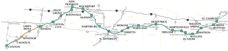
The Katy is a trail built on a former rail line of the Missouri-Kansas-Texas, or MKT railroad. There’s hope that the trail will be extended to the Kansas City area sometime in the future, but for now it runs for more than 220 miles from Clinton, 80 miles southeast of Kansas City, to St. Charles, a suburb of St. Louis.
Several years ago I talked my brother, Jim, and nephew, Chuck, into driving from Phoenix, and my nephew, Nick from Fargo, to do a self supported tour of the Katy Trail. We met at my house on Saturday and after last-minute preparations, got up Sunday to head for Clinton. My wife, Beth, agreed to ride along and bring the truck back home, and pick us up 4 days later on the other side of the state. We figured that we only needed to average about 60 miles a day to ride the entire trail in the time we had.

I had “promised” that June in Missouri would bring sunshine and warm temperatures. I lied. It was a little cool and just starting to drizzle as we left the Clinton trailhead and headed through rolling farmland. The rain got harder and colder as the afternoon went on. We layered as best we could but were still getting more and more miserable as the cold rain felt like sleet on our faces. We ended up at a Casey’s General Store in Green Ridge eating pizza and drinking hot chocolate. Weird combination, but the pizza was good, and the hot chocolate was hot, so there you go.
We made it only as far as Sedalia, 35 miles down the road. We had dinner at an Applebee’s and set up camp on the state fairgrounds. That night we survived thunderstorms and lightning, and by morning it seemed like everything we owned was wet. The only other tent campers were a father and son from Georgia riding cross-country, including the Katy Trail east-to-west. They awoke to a large tree branch next to their tent, but no harm done. A cup of coffee from a kind RV camper and a fast food breakfast, and we were on our way..…to the laundromat.
It took us a few hours to get everything dry; sleeping bags, shoes. But by noon, the sun was coming out and we were enjoying some nice scenery as we neared the Missouri river. We made about 65 miles to Boonville and camped out at New Franklin. It was becoming obvious that we wouldn’t make it to St. Charles, but the scenery was getting better, the weather looked like it would improve, and after a nice night around a campfire we were ready to roll.
On Tuesday we rode next to some nice wetlands with lots of wildlife sightings, through the MKT tunnel into Rocheport, a beautiful little town with B&Bs and the Trailside Café. It’s a great place for lunch or an ice cream. And you can rent a bike next door. Now we were along the stretch of the trail with towering limestone bluffs on the north side and the Missouri river to the south. We weren’t worried about making time or miles, just enjoying the ride, stopping to watch a barge float by, take a nap in the shade.

We made it as far as Tebbetts, about 55 miles. There was a small city park where we could set up tents. And , across the street, Turner’s General Store. We had read in a guidebook that Mrs. Turner and her husband had opened the store in 1933, and she was still running it near the end of the century. We checked the door and it was closed, even though it was mid-afternoon. We waited out front and eventually she returned from somewhere and let us in. This would be an adventure too.
We picked up candy, chips, water, pop and some bread, and found some kind of turkey loaf in her cold section. Bless her soul, Mrs. Turner didn’t seem real confident about running the meat cutter. At this point Jim and Nick went outside to wait, thinking this may not end well. Chuck told her he had worked in restaurants and she gladly let him work the machine. She rang up all of our shopping on an ancient register, and came up with a total of just over $8.00. I told her I didn’t think that sounded right, so she let me come behind the counter and add it up. It ended up being closer to $30.00. She was appreciative and said that she had been told by people that she could trust bikers riding the Katy Trail.
More rain that night, but another nice day on Wednesday as we rode to McKittrick. We weren’t going to be able to make it much further so we went south over one of the few bridges over the river in that part of the state. Crossing the busy bridge we saw a small kitten that had been abandoned on the side of the road. Wet and cold, we made a nest in a handlebar bag and after getting directions, dropped her at the vet in Hermann, with a donation to help with the expense of finding a home for her.
We called Beth and told her where we would be when she came to retrieve us the next day. As we set up our tents in the beautiful city park near a small creek, the sheriff came and suggested we move to higher ground as they were expecting some flooding. We doubted the story, but moved anyway. Sure enough, we would have been swimming if we had stayed put. As it was, the ground near us became so wet that as we sat in the shelter waiting for Beth we watched in amazement as thousands, maybe millions of earthworms headed for higher ground. The concrete platform of the next shelter was totally covered in worms.
It was a great 4 days on the trail, our only disappointment that we couldn’t ride the whole way to St. Charles. I went back by myself that Labor Day weekend on Saturday morning. I parked at McKittrick and rode the last 75 miles to St. Charles. The campground mentioned in the guidebook turned out to not cater to tent campers, and I was too hot and tired to ride far for another campground, so I ended up at a motel for the night. In the early morning I got back on the trail and rode back to McKittrick, and drove home.
I would like to get back to the Katy Trail and ride the most scenic parts in small pieces. But, if they ever get it done I would love the idea of riding all the way across the state on the trail.
The Katy is a trail built on a former rail line of the Missouri-Kansas-Texas, or MKT railroad. There’s hope that the trail will be extended to the Kansas City area sometime in the future, but for now it runs for more than 220 miles from Clinton, 80 miles southeast of Kansas City, to St. Charles, a suburb of St. Louis.
Several years ago I talked my brother, Jim, and nephew, Chuck, into driving from Phoenix, and my nephew, Nick from Fargo, to do a self supported tour of the Katy Trail. We met at my house on Saturday and after last-minute preparations, got up Sunday to head for Clinton. My wife, Beth, agreed to ride along and bring the truck back home, and pick us up 4 days later on the other side of the state. We figured that we only needed to average about 60 miles a day to ride the entire trail in the time we had.
I had “promised” that June in Missouri would bring sunshine and warm temperatures. I lied. It was a little cool and just starting to drizzle as we left the Clinton trailhead and headed through rolling farmland. The rain got harder and colder as the afternoon went on. We layered as best we could but were still getting more and more miserable as the cold rain felt like sleet on our faces. We ended up at a Casey’s General Store in Green Ridge eating pizza and drinking hot chocolate. Weird combination, but the pizza was good, and the hot chocolate was hot, so there you go.
We made it only as far as Sedalia, 35 miles down the road. We had dinner at an Applebee’s and set up camp on the state fairgrounds. That night we survived thunderstorms and lightning, and by morning it seemed like everything we owned was wet. The only other tent campers were a father and son from Georgia riding cross-country, including the Katy Trail east-to-west. They awoke to a large tree branch next to their tent, but no harm done. A cup of coffee from a kind RV camper and a fast food breakfast, and we were on our way..…to the laundromat.
It took us a few hours to get everything dry; sleeping bags, shoes. But by noon, the sun was coming out and we were enjoying some nice scenery as we neared the Missouri river. We made about 65 miles to Boonville and camped out at New Franklin. It was becoming obvious that we wouldn’t make it to St. Charles, but the scenery was getting better, the weather looked like it would improve, and after a nice night around a campfire we were ready to roll.
On Tuesday we rode next to some nice wetlands with lots of wildlife sightings, through the MKT tunnel into Rocheport, a beautiful little town with B&Bs and the Trailside Café. It’s a great place for lunch or an ice cream. And you can rent a bike next door. Now we were along the stretch of the trail with towering limestone bluffs on the north side and the Missouri river to the south. We weren’t worried about making time or miles, just enjoying the ride, stopping to watch a barge float by, take a nap in the shade.

We made it as far as Tebbetts, about 55 miles. There was a small city park where we could set up tents. And , across the street, Turner’s General Store. We had read in a guidebook that Mrs. Turner and her husband had opened the store in 1933, and she was still running it near the end of the century. We checked the door and it was closed, even though it was mid-afternoon. We waited out front and eventually she returned from somewhere and let us in. This would be an adventure too.
We picked up candy, chips, water, pop and some bread, and found some kind of turkey loaf in her cold section. Bless her soul, Mrs. Turner didn’t seem real confident about running the meat cutter. At this point Jim and Nick went outside to wait, thinking this may not end well. Chuck told her he had worked in restaurants and she gladly let him work the machine. She rang up all of our shopping on an ancient register, and came up with a total of just over $8.00. I told her I didn’t think that sounded right, so she let me come behind the counter and add it up. It ended up being closer to $30.00. She was appreciative and said that she had been told by people that she could trust bikers riding the Katy Trail.
More rain that night, but another nice day on Wednesday as we rode to McKittrick. We weren’t going to be able to make it much further so we went south over one of the few bridges over the river in that part of the state. Crossing the busy bridge we saw a small kitten that had been abandoned on the side of the road. Wet and cold, we made a nest in a handlebar bag and after getting directions, dropped her at the vet in Hermann, with a donation to help with the expense of finding a home for her.
We called Beth and told her where we would be when she came to retrieve us the next day. As we set up our tents in the beautiful city park near a small creek, the sheriff came and suggested we move to higher ground as they were expecting some flooding. We doubted the story, but moved anyway. Sure enough, we would have been swimming if we had stayed put. As it was, the ground near us became so wet that as we sat in the shelter waiting for Beth we watched in amazement as thousands, maybe millions of earthworms headed for higher ground. The concrete platform of the next shelter was totally covered in worms.
It was a great 4 days on the trail, our only disappointment that we couldn’t ride the whole way to St. Charles. I went back by myself that Labor Day weekend on Saturday morning. I parked at McKittrick and rode the last 75 miles to St. Charles. The campground mentioned in the guidebook turned out to not cater to tent campers, and I was too hot and tired to ride far for another campground, so I ended up at a motel for the night. In the early morning I got back on the trail and rode back to McKittrick, and drove home.
I would like to get back to the Katy Trail and ride the most scenic parts in small pieces. But, if they ever get it done I would love the idea of riding all the way across the state on the trail.
Sunday, October 25, 2009
cold, with warm memories
The weather has been cold. And I have a cold. And the cold, hard truth is I haven't been on my bike for a while. But I still have been reading, thinking, dreaming about biking. Daydreaming about adventures to come, and remembering rides from the past.
In the fall of 2005, my sister's husband, Bruce, told me he read a write-up of the inaugural Tour de Kota that had taken place that summer. He was thinking about signing up the following year and asked if I would be interested. I liked riding my bike, and I liked not going to work, so taking a week off to ride my bike? What's not to like! So we registered, and planned, and waited. And the second week of June, 2006 I headed for South Dakota.
The route for the 2nd annual TdK was from Yankton to Milbank, from the southeast corner of South Dakota to the northeast. We met in Milbank on Saturday morning for the shuttle to Yankton where the ride would start the next day. Bruce had some points to use, so he had booked a room at the Holiday Inn Express. Sunday’s ride was a loop from Yankton to Vermillion and back. Though I felt that we might be missing out by not camping with all of those at the park by the river, by the time we had done 80-some miles in a cold drizzle, the hot tub at the motel was a welcome sight. And we still had four nights to enjoy the camping experience.
Monday we rode out of Yankton and climbed the bluffs along the Missouri under a clear, blue sky. We headed north through rolling farmland and past Mennonite communities where I waved at a woman and several children sitting on the side of a hill, waving at the riders as they passed as we made our way to Freeman.
The next day was a century ride to Garretson. We crossed over I-29 and crossed briefly into Iowa before rolling into Garretson. We enjoyed dry, blue skies again, but the temperatures climbed into the 90s by mid-afternoon. I skipped the last rest stop as I rolled through Canton and ran out of water about 15 miles from Garretson. Some salted nuts and a bottle of water at the first gas station I saw got me to the end of the century tired, but pleased.
Wednesday we rode to Volga. By late morning we saw lightning on the horizon. As it neared, we took shelter in a barn with several other riders and waited for the storm to pass. We rode another couple hours before the rain started again. After a stop for drinks and snacks it seemed to let up a little so I headed out again.
Several miles down the road it started to pour again. I saw a couple of bikes turn in a driveway and I followed them. It turned out to be an indoor bait farm, and they welcomed us in to wait out the rain again. There was a huge bull mastiff wandering around the place that delighted in making friends with a couple of teenage boys who were riding with their Dad. He sat on their feet while they scratched his ears.
I eventually rolled into Volga, desperately in need of shedding my wet bike shorts. A hot shower never felt so good. They had us camping in the city park, complete with beer garden and entertainment. Scandinavian clog dancers were followed by a guy with a Scandinavian name singing some pretty good blues. There was a lot of good food available too, including pie from the ladies of the Lutheran church.
Thursday we rode in a monster cross-wind as we rode east. It was the kind of wind that makes it hard to stay upright on your bike. It was a pleasant change to turn north and have the wind at our back for a while. We were able to sustain some speed for several miles and were rewarded with a rest stop at the Lake Cochrane recreation area where we enjoyed sandwiches and root beer floats. Then we had to head back west towards Clear Lake, fighting rolling hills and cross-winds again. The local people arranged for transportation from the fairgrounds where we were camping, into town to enjoy the local restaurants and bars including a horse-drawn carriage and a party bus.
Friday we rode out of Clear Lake in a northerly direction. The miles, rain, cold and wind had started to take their toll on me, and I was close to a cumulative bonk as I pulled into the rest stop in the old school in Strandburg. It turns out a cup of coffee, a bottle of Gatorade, and a jelly doughnut was all I needed. I headed toward Milbank with renewed vigor. The 57 miles for the final day included taking a left turn on Highway 12 and several miles up the hill to Blue Cloud Abbey. Then we doubled back heading west into Milbank. It was tempting to skip the side trip, but the TdK’s motto is “miss a mile, miss a lot”. And the chance to see the Benedictine monastery was worth the trip.
As we rolled into Milbank passing cars would lightly tap their horns and wave encouragement to us for having made it to the very end. It wasn’t cowbells, but it was nice. I’m pretty easy, but it did bring a little tear to my eye. It pales in comparison to a lot of things, but I had a real feeling of accomplishment and desire to do more.
Now, every time I drive through South Dakota from Kansas to my hometown of Fargo, North Dakota, the names of the towns on the exit signs mean more to me than they ever did before. I’ve met some of the people, seen their towns, and experienced their hospitality. I’ll always have fond memories of that trip. And because I was able to do that, I’ve been willing to try more.
Sunday, October 11, 2009
what I need
I took my dogs for a walk this morning, as I do every morning, and one thing I can say with certainty: it's cold! Near freezing this morning, not much warmer now. A high predicted for the mid-40s with rain moving in. The leaves are changing colors and starting to drop from the branches. I love warm fall days followed by cool, window-open, good-sleeping-weather nights. What I don't care for is winter trying to take the stage before her cue.
The last couple of months have featured only a handful of rides. It's been work, weather, and other obligations. But those are all excuses. As much as I enjoy the trips I've made to Colorado to ride in the mountains, when I get back home, the farmland of eastern Kansas pales in comparison. There's nothing wrong with re-living the past, remembering people, places, and feelings of accomplishment. Nothing wrong with eagerly anticipating re-visiting adventures you've enjoyed, and tackling new ones.

But, I don't want to forget to live in the present, enjoy the ride for it's own sake. Even with this weather, I'm sure we'll enjoy several more weeks suitable to riding, layered as it may be. Then it will be indoors, on the trainer. I'm looking into a training DVD to help make the trainer more enjoyable: http://www.epicplanet.tv/catalog/ , but they had to postpone filming in Colorado until next year. So, I need to get out on the road while I still can.
Maybe I need to find some new places to ride. I mean, the scenery in the mountains is spectacular, but part of what I love about riding there is seeing something I haven't seen before, the joy of discovery. If I can find some routes that I can reach from home, and maybe an organized ride to look forward to and train for, maybe I can re-ignite my spark.
Don't get me wrong, I'm still going to spend an inordinate amount of my free time reading about and planning for my next trip to Colorado. CRMBT will visit a few of my favorite places before moving on to some new ground, and giving me a second chance at Mt Evans. And I want to find another ride I have not done; BAK, CANDISC, RRIBT are a few, among many, that I would like to try.
The last couple of months have featured only a handful of rides. It's been work, weather, and other obligations. But those are all excuses. As much as I enjoy the trips I've made to Colorado to ride in the mountains, when I get back home, the farmland of eastern Kansas pales in comparison. There's nothing wrong with re-living the past, remembering people, places, and feelings of accomplishment. Nothing wrong with eagerly anticipating re-visiting adventures you've enjoyed, and tackling new ones.

Maybe I need to find some new places to ride. I mean, the scenery in the mountains is spectacular, but part of what I love about riding there is seeing something I haven't seen before, the joy of discovery. If I can find some routes that I can reach from home, and maybe an organized ride to look forward to and train for, maybe I can re-ignite my spark.
Don't get me wrong, I'm still going to spend an inordinate amount of my free time reading about and planning for my next trip to Colorado. CRMBT will visit a few of my favorite places before moving on to some new ground, and giving me a second chance at Mt Evans. And I want to find another ride I have not done; BAK, CANDISC, RRIBT are a few, among many, that I would like to try.
For now, though, I promise to take the next chance to ride, and get on the bike. I'll take the camera with me, and share anything new I can find. And, if you happen to find my mojo, please leave a message here. There is a reward!
Monday, October 5, 2009
i need more cowbell !
In the immortal words of Bruce Dickinson, "I need more cowbell!" Cowbells have long been a staple for fans of professional cycling. They make a great noise-maker to cheer on your favorite rider or team as they sprint to the finish.


At my age I don't think I'll ever ride in the Tour de France, or even the Tour of Missouri (but wouldn't that be a great story?), but I'd still like to hear the cowbells. There were cowbells at the finish line for the Copper Triangle in August, and I've got to tell you, it was a thrill.

I enjoyed the idea of a noise-maker to celebrate an accomplishment so much, that when I arrived at the summit of Slumgullion Pass on CRMBT, I found an empty plastic bottle, and a rock to hit it with to welcome the rest of my group.

At the final stage of the Tour of Missouri in Kansas City, I picked up a small cowbell provided by the KC Parks Department. I plan to have this on my bike during the next organized ride I get to do. I'm even looking into buying some extras to give to fellow riders and volunteers who display exceptional enthusiasm for the accomplishments of the participants.
I want to start a groundswell so that any time you ride a MS150, group century, or multi-day tour, you'll hear a cowbell along the way. I know that personally, a cowbell at the top of Mt. Evans would be a memory I would never forget. Who's with me? I need more cowbell!
Tuesday, September 29, 2009
men's weekend
No time on the bike this weekend. I drove a few hours into Missouri to Lightfoot Park on Pom de Terre Lake to spend some time with some buddies. Brad and I worked together several years ago, and though we don't get to see each other often, we've remained friends.


About 8 years ago Brad invited me to men's weekend. Several guys who had been camping and skiing with their families thought it would be fun to have one weekend a year for just "the guys". So, in the early 90's they started heading to the lake on the last weekend in September.

Brothers, brothers-in-law, friends from college, and a few others get together to ski, golf, sit around the fire, play some games and give each other a hard time. Some years there's a canoe or a sailboat. Some years we set up a volleyball net. We always stay up late, enjoy catching up and laughing at each other, and our selves. It's just a couple days, but there's time to read, nap, and just hangout, and it's a pretty nice place to do it.

Four of us drove around the lake on Saturday to a little golf course on rolling hills that overlooks the lake on a hole or two. We were pushing it a little to get 18 holes in before it was too dark, but a golf course is such a beautiful place to be as the sun goes behind the trees and adds some color to the clouds in the sky.

Sunday, September 20, 2009
elevation
CRMBT announced it's route for 2010 earlier this week. Sounds like a great way to spend the first week of August. The route is a loop starting and ending in Edwards, CO, just west of Vail on I-70. Over Battle Mountain Summit and Tennessee Pass through Leadville, crossing Fremont Pass on the way to Frisco.


Then around Dillon Lake and over Swan Mountain to Keystone before climbing Loveland Pass on the way to Idaho Springs. Loveland reaches 11,990 feet, but the day's ride is only about 50 miles. That's good, because you'll want to save a little for what comes next! From Idaho Springs the route takes you 14 miles up to Echo Lake.
From there, you can head east over Squaw Pass, and eventually down Lookout Mountain into Golden. Or, if you have an itch you need to scratch, you can pay your $3 and head up Mount Evans Road. Highway 5 is the highest paved road in the US, rising from just over 10,000 feet at Echo Lake, to over 14,200 feet at the summit.
When I went to Colorado in June for BTC, I entertained the idea of riding up Mount Evans on my own. But, it was too much. Too cold, too high, too steep, too early in the season. It was an experience just to drive to the top, but I couldn't help but think that I'd like to have someone with me, if for nothing else, than to point to where I went off the road for the search and rescue team. But if it was August, a little warmer, and there were other riders on the road with me....
Anyway, from Echo Lake on will all be new territory for me, on a bike or in a car. From Golden the route follows the Peak-to-Peak Highway to Estes Park for a rest day. Then it's through the Rocky Mountain National Park on Trail Ridge Road. I found this picture on cyclepass.com:
http://cyclepass.com/index_p.html
The highest point on Trail Ridge Road is 12,183 feet, and you're above 11,000 feet for over 8 miles!
The last day is a little flatter, a little longer, with a 102 mile century ride to get back to Edwards.
This looks like another fantastic route. I'm especially pleased that some of the tough climbs come on days without brutal mileage. I know I'll have to train hard to be ready for this, but that's one of the advantages to an August tour, you have more of the summer to ride in preparation. I might need to look into a better headlight too, because if I want to make it from Idaho Springs to the top of Mount Evans and be headed down before the afternoon showers move in, I'll need to make that one an early start.
I'm not a fast rider, but the altitude hasn't affected me, and I've been able to climb all the climbs that CRMBT has put in front of me. I would like to be able to climb a little faster. If anyone has any training tips that I can use over the winter on the trainer, or next spring back on the bike, I'm open to suggestions.
Subscribe to:
Posts (Atom)